SF's Southern Edge: Difference between revisions
(addition of categories, photo credits) |
mNo edit summary |
||
| Line 1: | Line 1: | ||
[[Image:bayvwhp$sierra-pt-1926.jpg]] | [[Image:bayvwhp$sierra-pt-1926.jpg]] | ||
'''Sierra Point c. 1926''' | '''Train coursing the shoreline around San Bruno Mountain at tip of what is now Sierra Point, c. 1926''' | ||
''photo: San Francisco History Center, San Francisco Public Library'' | ''photo: San Francisco History Center, San Francisco Public Library'' | ||
[[Image:bayvwhp$oyster-pt-1976.jpg]] | [[Image:bayvwhp$oyster-pt-1976.jpg]] | ||
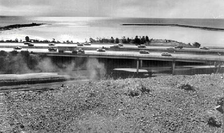
'''Oyster Point c. 1976''' | '''Oyster Point c. 1976. Brisbane Lagoon hasn't yet been filled as a dump, and there isn't yet any Highway 101.''' | ||
''photo: San Francisco History Center, San Francisco Public Library'' | ''photo: San Francisco History Center, San Francisco Public Library'' | ||
[[Before the Navy, Hunters Point was home to a Chinese shrimping village. In 1938 the Fire Department burned the remaining structures to make way for the Navy. In 1941, the 250-foot tall Avisadero Point at the very eastern end of the Point was dynamited and turned into landfill. Prev. Document]] [[Bayshore views Next Document]] | [[Before the Navy, Hunters Point was home to a Chinese shrimping village. In 1938 the Fire Department burned the remaining structures to make way for the Navy. In 1941, the 250-foot tall Avisadero Point at the very eastern end of the Point was dynamited and turned into landfill. Prev. Document]] [[Bayshore views Next Document]] | ||
[[category:Bayview/Hunter's Point]] [[category:Shoreline]] [[category:Water]] [[category:1920s]] [category:1970s]] [[category:Roads]] [[category:Trains]] | [[category:Bayview/Hunter's Point]] [[category:Shoreline]] [[category:Water]] [[category:1920s]] [category:1970s]] [[category:Roads]] [[category:Trains]] | ||
Revision as of 00:14, 17 August 2008
File:Bayvwhp$sierra-pt-1926.jpg
Train coursing the shoreline around San Bruno Mountain at tip of what is now Sierra Point, c. 1926
photo: San Francisco History Center, San Francisco Public Library
Oyster Point c. 1976. Brisbane Lagoon hasn't yet been filled as a dump, and there isn't yet any Highway 101.
photo: San Francisco History Center, San Francisco Public Library
[[Before the Navy, Hunters Point was home to a Chinese shrimping village. In 1938 the Fire Department burned the remaining structures to make way for the Navy. In 1941, the 250-foot tall Avisadero Point at the very eastern end of the Point was dynamited and turned into landfill. Prev. Document]] Bayshore views Next Document [category:1970s]]

