Marina: Difference between revisions
(Added neighborhood description) |
No edit summary |
||
| (3 intermediate revisions by the same user not shown) | |||
| Line 1: | Line 1: | ||
[[Category:Neighborhood/Geography]] | [[Category:Neighborhood/Geography]] | ||
[[Image: | [[Image:Marina District crushed car 009sr.jpg|720px]] | ||
''' | '''An automobile lies crushed under the third story of this apartment building in the Marina District. The ground levels are no longer visible because of structural failure and sinking due to liquefaction.''' | ||
''Photo: | ''Photo: Oct. 17, 1989 by J.K. Nakata, courtesy U.S. Geological Survey'' | ||
''Text partially excerpted from 'The District Handbook: A CORO Foundation Guide' | '''Text partially excerpted from 'The District Handbook: A CORO Foundation Guide'''' | ||
The Marina District was created by landfill for the site of the Panama Pacific Exposition in 1915. The Exposition was constructed to celebrate the opening of the Panama Canal. It covered over 635 acres with ten exhibition halls. The only remnants from the fair are the Yacht Harbor and the [ | The Marina District was created by landfill for the site of the Panama Pacific Exposition in 1915. The Exposition was constructed to celebrate the opening of the Panama Canal. It covered over 635 acres with ten exhibition halls. The only remnants from the fair are the Yacht Harbor and the [[The_Palace_of_Fine_Arts| Palace of Fine Arts]]. | ||
In the Marina beautiful homes with spectacular views of the Bay were built right across from the Marina Green. The Green became a favorite location for kite flyers despite and early ordinance that expressly prohibited the flying of kites. | In the Marina beautiful homes with spectacular views of the Bay were built right across from the Marina Green. The Green became a favorite location for kite flyers despite and early ordinance that expressly prohibited the flying of kites. | ||
In 1989 a 7.1 earthquake stunned the city and devastated sections of the Marina District. More than 30 structures were destroyed. | In 1989 a 7.1 earthquake stunned the city and devastated sections of the Marina District. More than 30 structures were destroyed. | ||
Latest revision as of 22:34, 29 April 2021
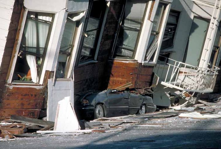
An automobile lies crushed under the third story of this apartment building in the Marina District. The ground levels are no longer visible because of structural failure and sinking due to liquefaction.
Photo: Oct. 17, 1989 by J.K. Nakata, courtesy U.S. Geological Survey
Text partially excerpted from 'The District Handbook: A CORO Foundation Guide'
The Marina District was created by landfill for the site of the Panama Pacific Exposition in 1915. The Exposition was constructed to celebrate the opening of the Panama Canal. It covered over 635 acres with ten exhibition halls. The only remnants from the fair are the Yacht Harbor and the Palace of Fine Arts.
In the Marina beautiful homes with spectacular views of the Bay were built right across from the Marina Green. The Green became a favorite location for kite flyers despite and early ordinance that expressly prohibited the flying of kites.
In 1989 a 7.1 earthquake stunned the city and devastated sections of the Marina District. More than 30 structures were destroyed.
Pages in category "Marina"
The following 46 pages are in this category, out of 46 total.

